


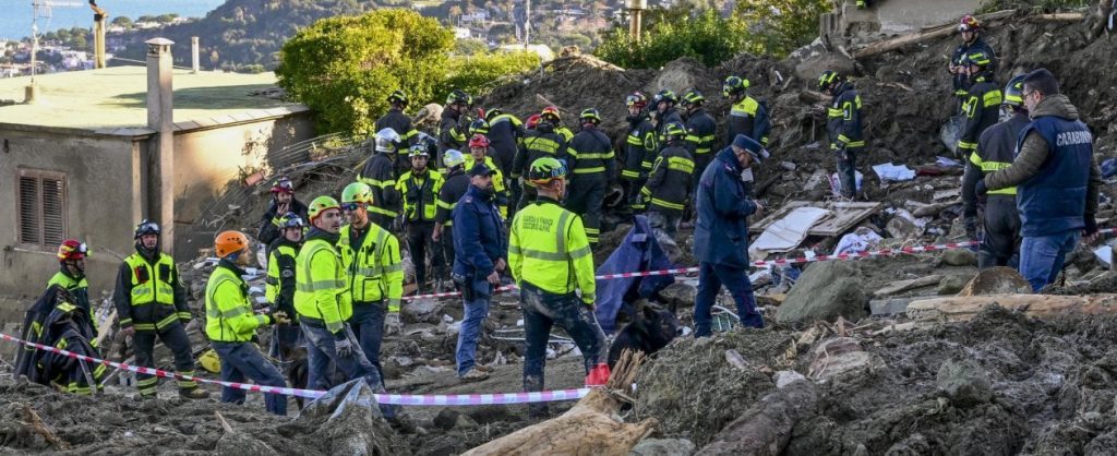
“The tragic consequences of the landslide in Ischia could have been avoided if satellites had been used. Those of the CosmoSkyMed constellation of the Italian Space Agency (ASI) are able to monitor even small movements of the Earth, even millimeters in the case of buildings, bridges and viaducts so they are particularly suitable for forecasting. “. with landslides, allowing the warning to be sounded hours in advance. In short, many lives could have been saved. The same in the case of the Genoa Bridge: with a simulation we verified that the CosmoSkyMed satellites would have noticed the deformations that the structure had suffered and the tragedy would have been averted.” Let’s say it’s Rodolfo Gozzi, a physicist at the Italian Space Agency who made an important contribution to CosmoSkyMed and who won the 2021 Antonio Feltrinelli Prize for Astronomy and Geophysics.
In Italy, with a 20% risk of landslides, having such an advantage could make a difference. If it is clear that the fragility of the region must be addressed by resolving the causes (soil depletion and hydrogeological instability), it is necessary to control the risks of unexpected extreme events.
A new topic entered this environmental monitoring activity: space. The images captured by the satellites are able to provide key information for identifying new landslides, keeping existing landslides under control and managing emergencies. That is, make effective prevention.
An example comes from the municipality of Messina: in the small village of Altolìa, an environmental monitoring model has been developed – that can be replicated anywhere – that links data received from space with field surveys. The information is provided by CosmoSkyMed’s constellation satellite sensors that visualize the area through high-resolution image processing. They detect ground movements not only due to landslides, but also earthquakes and volcanic eruptions.
“The problem is that this data collected by the Italian Space Agency and e-Geos is not used as it should,” adds Rodolfo Gozzi. “It is clear, in fact, that satellites cannot give a warning in real time, they are not installed on every landslide. But by processing their data, that is, the beginning of the alert phase, the development of the phenomenon can be expected in the following hours, and therefore in time. Unfortunately, it did not This happens.”
Satellites are actually able to help us in many areas. Since being launched into orbit, the CosmoSkyMed satellite constellation has spotted 7 billion square kilometers, about 14 times the total area of planet Earth. And this is just a small part of the thousands of satellites orbiting above our heads. From the beginning of the space age until today — Sputnik was put into orbit by the Soviet Union in 1957 — some 11,000 satellites have been launched, of which 7,289 are still in orbit (about 4,000 are active).
According to estimates from the European Exhibition of the New Space Economy, an event organized by the E. Amaldi Foundation and Fiera Roma, the space economy will reach a thousand billion euros in the next few years. “We have realized that exploiting decades of investments in the space sector is the most effective tool for achieving the new sustainability goals and supporting the economy of the coming decades,” says Rodolfo Gozzi.
Precisely to protect the planet, information collected by satellites can make a difference in many areas: from deforestation to air pollution, from sea level rise to desertification, from agriculture to melting glaciers.
In Indonesia’s Leuser National Park, orbiting satellites protect the natural habitat and thus ensure the survival of orangutans. Thousands of images from space are analyzed and compared. By observing the contrast of pixels from green to brown, we recognize when we are entering an emergency situation.
But perhaps agriculture is the sector in which the contribution of satellites appears to be the most interesting development, as evidenced by the interest of many farms on the peninsula. At Jolanda di Savoia in Ferrara, the 615km-high Prisma satellite monitors crop growth cycles, assesses water needs, reduces waste by up to 40%, monitors plant health, and optimizes pesticide and fertilizer use.
Not only. “Thanks to ultra-spectral sensors capable of collecting a lot of information, Prisma – created by the Italian Space Agency – can also find applications in the management of climatic and environmental changes by providing data on water quality, particles and pollutants present in the atmosphere”… he concludes Rodolfo Jose.

“Internet trailblazer. Travelaholic. Passionate social media evangelist. Tv advocate.”
More Stories
The best match of the season came on Matchday 34: 90 minutes of desire and enthusiasm
See what the speed of light looks like on Earth – the video is amazing
Franco Di Mare is with him during his illness. His “women”: his daughter Stella, whom he adopted in Kosovo, his sisters, and his partner, Julia. “I was running alone”